My sister is nearing the end of her fortnight walking the Pennine Way (see earlier posts here and here) and I have been thinking so much of her as she strides out each day, whilst I sit in the night time of the Southern Hemisphere feeding Alice. The updates from my Dad have been greatly anticipated each day. Both him and my Mum have been supporting Claire enroute, joining her for parts of the walk.

10 July:
Claire & I at top of Great Shunner Fell this morning. Damp but happy.
Dined tonight at the Tan Hill Inn – highest pub in England (1,732 ft). Photo of Tan Hill Inn with emergency arctic tractor used in winter. Had a great night and a lovely meal. Met a most eclectic bunch of people including those doing both the Pennine Way and the Coast to Coast.
We left Claire in the bunk house while we went down hill to village of Muker to a really nice B&B! – Muker is very close to Keld which is the crossing point of the Pennine Way and Coast to Coast so lots of walkers in the cafes, pubs and camp sites.
By the time we arrived after 9am she was off on her way to Middleton in Teesdale (16 miles).

She’s walking further than the distance between Wellington and Taupo, with an overall ascent bigger than climbing Everest (but obviously without the altitude challenges!). Though New Zealand is magnificently beautiful and has some amazing ‘Great Walks’ they are just that, designated walks within the bounds of National Parks. The one aspect of walking I miss out here is the absence of Public Right’s of Way, which in England stem from the historic right to walk across the land and have remained in place through all the changes to the landscape. Therefore it is possible to walk large distances across the British landscape far away from the main highways. The other aspect of walking in Britain is the history and the public houses (pubs) dotted across the land.
11 July:
Claire and Mum crossing the river Tees at the end of the day. It was a bit damp in the morning but nice by the end of the day. Mum encouraged Claire to do a few extra miles up the river at the end of the day so that the next big day would be easier.

Stopped overnight at YHA Langdon Beck near Forest-in-Teesdale. The upper end of the Tees valley is a wild but wonderful place. Spotted a merlin 5 fence posts away in addition to lots of other moorland birds. Local pub was within walking distance and served great food. Also had 21 cyclists at the YHA. A good night was had by all but we have been eating early and getting to sleep by 10 completely exhausted.
12 July:
Claire walked across the Pennines today from Teesdale in County Durham to Dufton near Appleby-in-Westmoorland (now in Cumbria). This is a fantastic 20 miles which include High Force (highest waterfall in England), Cauldren Snout (see pic) and High Cup Nick.

We parked at a reservoir and met Claire at Cauldren Snout. Wind was gale force with occasional light rain but she decided to continue. Wind eased a little and rest of day was bwilliant! – see pic across village green from Dufton YHA.

13 July:
19 miles today from Dufton to Alston. First pic from cafe at 1900 ft as mum and I drove across – higher than highest pub!

I walked back to meet Claire at Gregs Hut – a refuge just below the peak of Cross Fell – second pic.
Mum and I also walked back to meet Claire as she arrived in Alston so done 15 miles myself today plus a lot of height. Had really good meal in local pub near YHA and now crashing out just after 10 again.

14 July:
7 miles up to Greenhead on Hadrian’s Wall. Journey was mainly along a wide valley with lots of fields, stiles, vegetation and frustrating navigation. Claire was rewarded with a fabulous Indian meal in the old market town of Hexham.
15 July:
It was a very misty and damp start – “dreek” as your Mum would say. Claire stepped out from Greenhead while we drove to Housesteads to meet her. All finished by lunchtime so in the afternoon we visited a large active archealogical dig – Vindolanda – which was fantastic.

Went to Hexham in the afternoon for some retail therapy plus a very necessary new pair of boots for me. My old ones gave up the ghost with a large split after walking about 15 miles on Monday.
16 July:
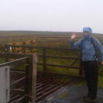
Today we left Hadrian’s Wall and headed north across Northumbria’s moorlands towards the Cheviot hills which separate England from Scotland. Weather was a mix of sunny spells and very heavy showers. Claire got soaked twice while I got caught once while walking to meet her. We had to reach Bellingham (13 miles) but she managed to do 18 which leaves us in a really good position for the last 2 days – 38 miles.

Spent night in lovely B&B in countryside. Awakened at 5.00 am by strong winds. This was view from window. Just hope rain stays away and wind eases.

Related posts
 July 22, 2010 Signing off from the Pennine Way
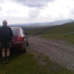 July 9, 2010 So proud of my sister!
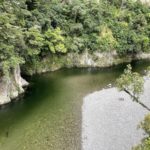 January 8, 2023 Summer highlights from the Wairarapa
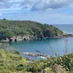 January 6, 2023 A long weekend with friends near Goat Island Marine Reserve
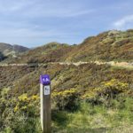 December 14, 2022 Spring running highlights on Wellington’s trails
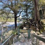 October 25, 2022 Trail goodness in the southern Remutaka Ranges
Gosh, what an amazing journey! I would love to do something like that one day!!
Your right it sounds like such a different ‘walk culture’. I can see such a journey would make a captivating ‘intrepid journey’s’ style show.
Can you really just walk through people’s farms or are there disignated walk ways within the private lands?
Hi Andrea, for more information I’d recommend visiting Natural England’s website. Walkways cover private land, with stiles to cross walls. There’s also some land open to roam freely. Ordnance survey maps provide details of the pathways. Cheers, Sarah
I’ve done numerous walks in that part of the country, but never end to end.
Interesting to hear that NZ doesn’t have the same kind of lengthy footpaths – I’d assumed it would be a dream country for walkers.
Hi Rachel, New Zealand does have some very long walks, but there isn’t the access to private land that exits in the UK. The Department of Conservation list all the ‘Great Walks‘, which really are spectacular. Sarah x
lovely blog…I was always very pleased to see Claire pop up over the hills as we journeyed on our way and daddy often walked back to meet her…fussy mum as you know and will never change…thank you for reminding me of these lovely pictures and also so good to know all well in New Zealand…what special photos of you all near and far!!